Introduction
Discover the allure of Bloomingdale Trail, a hidden gem nestled in the heart of Chicago. Our in-depth guide unveils the rich tapestry of this urban oasis, enticing both locals and visitors to explore its wonders.
The Origin Story
Bloomingdale Trail, often referred to as The 606, boasts a captivating history that adds layers to its charm. Originating from a former rail line, this elevated trail transformed into a recreational haven, seamlessly blending the past with the present.
Homes For Sale Near the 606
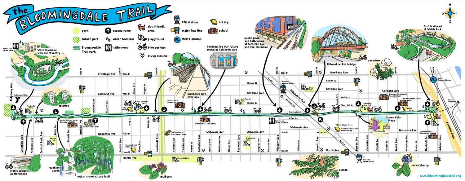
The Bloomingdale Trail stretches across 2.7 miles (4.3 km) as an elevated rail trail linear park, extending from east to west on the northwest side of Chicago. This marks a significant milestone as the longest greenway project crafted from a former elevated rail line in the Western Hemisphere. Globally, it claims the title of the second-longest, surpassed only by the Promenade plantee linear park in Paris. In a transformative move in 2015, the City of Chicago repurposed the erstwhile Bloomingdale railway line into an elevated greenway, serving as the foundational element for the extensive 606 trail network. Positioned within and adjacent to the Chicago neighborhoods of Logan Square, Humboldt Park, Wicker Park, Bucktown, West Town community areas, the Bloomingdale Trail elevated park stands as a testament to urban innovation and community development.
History of the Bloomingdale Trail (The 606)
In 1873, the Chicago & Pacific Railroad Company laid the groundwork for the Bloomingdale Line, a segment of the 36-mile (58 km) Elgin subdivision. Stretching from Halsted Street in Chicago to Elgin, Illinois, the line quickly fell under the umbrella of the Chicago, Milwaukee, St. Paul and Pacific Railway, better known as the Milwaukee Road. Initially leased for 999 years in 1880, it was eventually deeded to the Milwaukee Road in fee simple in 1900.
Talk with a Logan Square Real Estate Agent
In a pivotal turn of events, the Soo Line Railroad, a subsidiary of the Canadian Pacific Railway, assumed control in 1986, acquiring the assets of the Milwaukee Road after its bankruptcy. The City of Chicago took ownership of the property’s right-of-way from Canadian Pacific in January 2013.
To address safety concerns, the rail line underwent a significant transformation in the 1910s. Elevated by approximately twenty feet, this initiative, spurred by a city ordinance to reduce pedestrian fatalities at grade crossings, reshaped Bloomingdale Avenue. Once a street-running railway along Bloomingdale Avenue, the embankment altered the street’s width, relegating parts of it to alleyways.
The corridor is now marked by steel-reinforced concrete embankment walls and 38 viaducts. Originally accommodating both passenger and freight trains, the Bloomingdale Line served local industrial businesses, including the Schwinn Bicycle Company warehouse.
Over time, it played a crucial role in connecting various Milwaukee Road tracks, such as the Chicago & Evanston Line (Lakewood Branch and Kingsbury Branch), remnants of the Deering Line, and Goose Island. By linking to the former Milwaukee Road tracks at C&E Junction, the Bloomingdale Line facilitated transportation east of the North Branch of the Chicago River.
While the line saw its last through freight train in 2001, Canadian Pacific continued to use it for storing freight cars and switching activities near Newly Weds Foods until 2012.
The Bloomingdale Avenue embankment extends beyond the trail terminus at Ridgeway Avenue, intersecting with Metra’s commuter tracks of the Milwaukee Road. Northbound North Line trains progress toward Fox Lake via the CP C&M Subdivision, while West Line trains traverse the Bloomingdale tracks west to Elgin through the CP Elgin Subdivision. The tracks eventually transition to surface-level on the western outskirts of the city.
Scenic Trail
In 1997, the City of Chicago initiated an exploration into the transformation of the Bloomingdale Line into a greenway. However, at that time, the railway remained in active use. The greenway concept was revisited and reintroduced as part of the Logan Square Open Space Plan between 2002 and 2004. This comprehensive plan envisioned a linear park or greenway featuring multiple public access ramps and a proposed trailhead at the east end, near the Chicago River.
In 2003, a grassroots non-profit organization called Friends of the Bloomingdale Trail (FBT) emerged as a key advocate for and participant in the conversion project. FBT collaborated with the City and The Trust for Public Land, a national non-profit land conservation group, in a partnership that led project management, design, and development efforts.
Phase II design services were entrusted to Collins Engineers, Inc. The groundbreaking ceremony, a symbolic commencement of the transformative project, took place on August 27, 2013, at what would later become the Milwaukee Avenue / Leavitt Street connection to the trail.
The Bloomingdale Trail, forming the backbone of the 606 parks and trail network, pays homage to the city’s ZIP Codes, all of which share the prefix 606. The trail spans from Ashland Avenue in the east to North Ridgeway Avenue in the west, running parallel to West Bloomingdale Avenue.
In November 2013, the Alphawood Foundation provided a substantial boost by offering a $2 million grant to fund the project. The park was officially inaugurated on June 6, 2015. Various proposals have emerged to link the trail to the former A. Finkl & Sons Steel property, a 22-acre site in Lincoln Park.
Beauty and Landscape
Nature’s Canvas
Embrace the breathtaking beauty of Bloomingdale Trail’s landscape. A harmonious blend of lush greenery, wildflowers, and artistic installations creates a picturesque scenery that captivates every visitor.
Architectural Marvels
Marvel at the seamless integration of urban architecture with natural surroundings. The trail’s design is a testament to modernity coexisting with nature, providing a unique and refreshing escape from the city’s hustle and bustle.
Annual 5K Run
Experience Breathtaking City Views on the Bloomingdale Trail Annual 5K Run
Embark on a thrilling journey above the Northwest side neighborhoods with the acclaimed Bloomingdale Trail Run. This annual event caters to families, offering a timed 5K run along with ¼- and ½-mile dashes designed for young participants.
Mark your calendars for our upcoming run scheduled for August 2024. Stay informed by subscribing to the newsletter, ensuring you receive timely updates on registration announcements!
The run commences and concludes on the west end of the Bloomingdale Trail at the McCormick YMCA (1834 N. Lawndale). Participants can enjoy a delightful spread of light breakfast treats, fresh fruit, and coffee as a token of appreciation.
Navigating The Bloomingdale Trail: Plan Your Visit
Access Points
Our guide provides detailed insights into accessible entry points, ensuring that both seasoned locals and first-time visitors can seamlessly navigate and explore Bloomingdale Trail.
- Situated in Chicago, the trail spans the 1800 block north, extending from Ashland (1600W) to Ridgeway (3750W), encompassing nearly three miles.
- Twelve ADA-compliant access ramps, spaced approximately every quarter of a mile, serve as the designated entry and exit points for the trail.
- The Bloomingdale Trail is most commonly accessed by walking, cycling, or utilizing public transit.
Restrooms & Hydration Stations
Publicly accessible restrooms are located behind the McCormick YMCA on Ridgeway and adjacent to the trail at the Trailhead building on Western. Additionally, water fountains are available at street level near every entrance, in Julia de Burgos Park, and along the trail at Western, Rockwell, and California.
Conclusion
In conclusion, the Bloomingdale Trail stands as a testament to the harmonious coexistence of urban innovation, community development, and natural beauty. From its humble origins as the Bloomingdale Line in 1873 to its transformative elevation in 2015, the trail has evolved into a captivating urban oasis.